Province of Isabela's 37 towns and cities

PHOTO LINKED FROM: https://upload.wikimedia.org/wikipedia/commons/thumb/e/ef/Political_map_of_Isabela%2C_Philippines.png/800px-Political_map_of_Isabela%2C_Philippines.png
Isabela, the second largest among the Philippines’ 80 provinces, is located on the northeastern seaboard of the island of Luzon – the biggest among the 7,107 islands comprising the Philippine archipelago.
With a total land area of 10,655 square kilometers comprising more the 3% of the Philippine territory and almost 40% of the Cagayan Valley region, Isabela is the largest province on Luzon Island. It is bounded on the north by Cagayan province; on the west by Kalinga, Mountain Province, and Ifugao; on the south by Nueva Vizcaya, Quirino, and Aurora; and on the east by the Philippine Sea and the Pacific Ocean. SOURCE: https://provinceofisabela.ph/index.php/general-info/geography

PHOTO LINKED FROM: https://en.wikipedia.org/wiki/Isabela_(province)#/media/File:Ph_seal_isabela.png
The following are Isabela's 37 towns and cities in alphabetical order. Note that Santiago is an independent component city and Cauayan is a component city.
The following are Isabela's 37 towns and cities in alphabetical order. Note that Santiago is an independent component city and Cauayan is a component city.
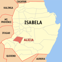
Alicia
Angadanan
Aurora
Benito Soliven
Burgos
Cabagan
Cabatuan
Cauayan
Cordon
Delfin Albano
Dinapigue
Divilacan
Echague
Gamu
Ilagan
Jones
Luna
Maconacon
Mallig
Naguilian
Palanan
Quezon
Quirino
Ramon
Reina Mercedes
Roxas
San Agustin
San Guillermo
San Isidro
San Manuel
San Mariano
San Mateo
San Pablo
Santa Maria
Santiago
Santo Tomas
Tumauini
This primarily agricultural province is the rice and corn granary of Luzon due to its plain and rolling terrain. In 2012, the province was declared as the country's top producer of corn with 1,209,524 metric tons.
Isabela is the 10th richest province in the Philippines in 2011. The province has four trade centers in the cities of Ilagan, Cauayan, Santiago and the municipality of Roxas. SOURCE: https://en.wikipedia.org/wiki/Isabela_(province)


Comments
Post a Comment